Raymarine E Series Installation Guide Page 167
- Page / 198
- Table of contents
- BOOKMARKS
- E-Series 1
- Networked 1
- Reference Manual 1
- Contents 3
- Contents iii 5
- Contents v 7
- Contents vii 9
- Important Information 11
- EMC conformance 12
- Multi-media chart cards 12
- Chapter 1: Overview 13
- Fishfinder 14
- Course deviation indicator 15
- Digital Instruments 15
- Engine Monitor 15
- 1.3 The Simulator 16
- Chapter 2: General Operation 17
- 2.3 Using the controls 18
- Buttons and soft keys 19
- The cursor 20
- ACKNOWLEDGE 21
- Accessing menus 22
- Selecting a page set 25
- Cautions 27
- How do I insert a card? 28
- How do I remove a card? 28
- Saving information to a card 29
- Note: Pressing the 30
- 2.10Emergencies and warnings 33
- How do I cancel an alarm? 34
- 3.1 What is a waypoint? 35
- Available waypoint 36
- Default symbol 36
- Alternative 36
- ... at the cursor? 37
- ... at my current position? 37
- ... at a known position? 37
- ...using the cursor 38
- ...via the WPTS MOB button 38
- Stop navigating to a waypoint 39
- ...using the waypoint list 40
- Changing waypoint details 41
- Moving a waypoint 42
- Erasing a waypoint 42
- Default Symbol 43
- Default Group 43
- My Waypoints 43
- Making a new waypoint group 44
- Renaming an existing group 46
- Erasing a group 46
- Display by symbol or group 47
- Display waypoint names 47
- Chapter 4: Using the Chart 49
- 4.3 Viewing the chart 50
- 4.4 The chart display 51
- 4.5 Where am I on the chart? 51
- Zooming in/out 52
- D 6771-1 53
- Displaying details of tides 54
- Search for a port 56
- Port symbol 57
- To position the ruler 58
- To reposition the ruler 58
- To clear the ruler 58
- Go to the cursor position 59
- Go to a waypoint 60
- Building a route 61
- Building routes on screen 62
- BUILD NEW 63
- USE THIS 63
- WAYPOINT 63
- : 64
- Following a route 65
- Follow using Quick Route 66
- Follow using the cursor 66
- Follow using the route list 66
- Follow in reverse order 67
- Viewing details of routes 68
- ... using chart vectors 69
- Wind and tide arrows 70
- CHART MODE AND 71
- ORIENTATION… 71
- RDR RNG SYNC 71
- ON OFF 71
- PRESENTATION… 71
- Chapter 5:Using the 72
- Chapter 5: Using the Radar 73
- What is a track? 74
- How can I use tracks? 74
- Creating a track 74
- Creating a route from a track 75
- ...from a saved track? 76
- To select a route 77
- To select a track 77
- Reversing a route 78
- ‘ 79
- PLACE WAYPOINT 80
- Using cross track error (XTE) 81
- , the route is 82
- Quick Route 82
- Erasing a route or track 83
- Local chart view 84
- System chart view 84
- North Up (N-up) 84
- True motion (TM) 86
- Autorange 87
- ... by group/symbol 87
- ... waypoint name 88
- Chart Setup 90
- Chart Offset 91
- Chart offset indicator 91
- Cartography set up 92
- Chapter 5:Using the Radar 95
- True echo Side echoes 97
- Main lobe 97
- Side lobe Side lobe 97
- Multiple echoes 98
- Blind sectors 98
- Sea clutter 98
- Rain clutter 99
- Interference 99
- (Rotating icon) 100
- (static icon) 100
- (greyed-out icon) 100
- (rotating/static icon) 100
- 101
- Head Up (H-UP) 102
- Setting the motion mode 103
- True Motion (TM) 104
- Using the GAIN functions 105
- Interference Rejection 108
- Expansion 108
- ... Using the range rings 109
- ... Using the cursor 110
- ... Using VRMs and EBLs 110
- ... Using floating VRMs/EBLs 111
- Guard Zones 112
- Sector guard zone 113
- 6nm Head-Up Relative Motion 113
- Rings 1nm 113
- Circular guard zone 114
- SAFETY NOTICES 115
- Introduction to MARPA 115
- How is a risk assessed? 116
- What happens to target data? 116
- Dangerous target 117
- Safe target 117
- Target being acquired 117
- Lost target 117
- Setting up MARPA 118
- How do I cancel targets? 119
- 5.11How do I set up my radar? 120
- 6.1 Introduction 123
- 200 kHz: Auto 124
- Gain: Auto High 124
- How are targets displayed? 125
- How do I see a live image? 127
- Changing the range 128
- Shifting the image 128
- Zooming in on the bottom 129
- Simplifying the bottom image 130
- Isolating bottom fish 132
- Adjusting the scroll speed 133
- Pausing the scrolling image 133
- Removing the depth digit 134
- TRANSDUCER 135
- SETTINGS… 135
- Using VRMs 137
- Transducer Calibration 139
- DSM Setup 140
- Controlling the image 141
- Operating frequency modes 142
- Gain modes 144
- Manual Gain Mode 145
- Color Gain 145
- TVG (Time Varied Gain) 145
- Gain adjust (200/50) 145
- Adjusting the power setting 146
- Indicator 147
- Instruction Cause 148
- 8.1 Introduction 149
- 9.1 Introduction 151
- Chapter 10:Video 153
- How do I run the video cycle? 155
- How do I adjust the image? 156
- Rename a page set 158
- System Setup 161
- Date/Time Setup Menu 162
- System Integration Setup Menu 163
- Alarm Setup Menu 164
- Navigation Alarms Setup 165
- Radar Alarms Setup 165
- Fishfinder Alarms Setup 165
- Fish Alarm Depth LImit 166
- Shallow Depth Alarm 166
- Deep Depth Alarm 166
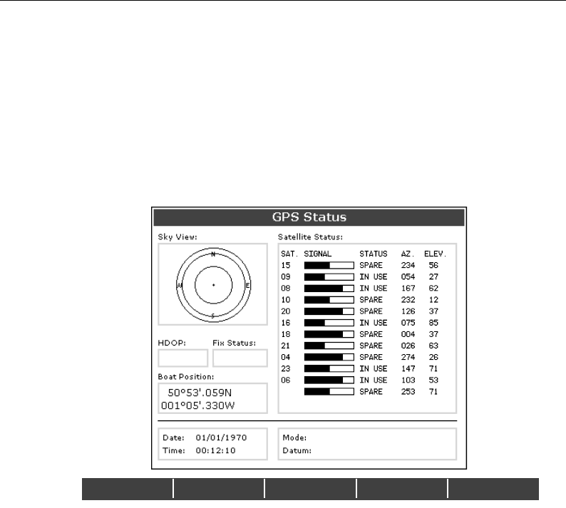
- GPS Status 167
- Compass Setup 167
- Display Setup 168
- Databar Setup 168
- Select Page Set 168
- System Diagnostics 168
- Remove CF Card 168
- 12.1Introduction 169
- 12.3How do I reset a Display? 170
- Settings and data reset 171
- Help us to help you 172
- World wide web 172
- E120 Displays 175
- Chartplotter Features 178
- Digital data 179
- Engine monitor 179
- Interfacing 180
- 4-42, 4-43 186
- 4-38, 5-10 197
Related products and manuals for Car navigation systems Raymarine E Series
 (30 pages)
© 2020, manymanuals.com. All rights reserved. | 1.527 s |
 Manymanuals.com
 Manymanuals.de
 Manymanuals.fr
 Manymanuals.it
 Manymanuals.pl
 Manymanuals.cz
 Manymanuals.es
 Manymanuals-pt.com
Comments to this Manuals